-
Ratonga
Services
Ratonga ServicesMore about Services
- Cemeteries
- Dogs and animals
- Doing business in New Plymouth
- Event planning
-
Licenses and regulations
Raihana me ngā whakaritenga Licenses and regulationsMore about Licenses and regulations
- Maps and GIS
- Paying us
- Report a problem
-
Transportation
Waka kawe TransportationMore about Transportation
-
Venues for hire
Ngā wāhi hei utu Venues for hireMore about Venues for hire
- Bell Block Hall
- Bowl of Brooklands
- Brian Bellringer Pavilion
- Ferndale Hall
- Fred Tucker Memorial Community Centre
- Govett-Brewster Art Gallery/Len Lye Centre
- Hempton Hall
- Inglewood Town Hall
- Merrilands Domain Hall
- Ōākura Hall
- Onuku Taipari Domain Hall
- Puke Ariki and Community Libraries
- Star Gymnasium
- Todd Energy Aquatic Centre
- TSB Showplace
- TSB Stadium
- Yarrow Stadium
-
Te Kāinga me ngā Taonga
Home and property
Te Kāinga me ngā Taonga Home and propertyMore about Home and property
-
Building and resource consents
Te whakaae me te whakahounga whakaaetanga Building and resource consentsMore about Building and resource consents
-
Building
Hangatanga BuildingMore about Building
- Apply for a building consent online
- Do I need a building consent?
- Residential building consents
- Commercial building consents
- Building on land subject to natural hazards
- Unpermitted or unrecorded building work
- Related approvals and project requirements
- Frequently asked questions
- Development contributions
- Earthquake prone buildings
- Eco design
-
Resource consents
Whakaaetanga Rauemi Resource consentsMore about Resource consents
- Subdividing land
- District Plan
- Activity in our district
- Liquefaction
-
Building
- LIMs
- Property
- Rates information
-
Water, wastewater and stormwater
Wai, wai paraawa, wai para Water, wastewater and stormwaterMore about Water, wastewater and stormwater
- Zero Waste
-
Building and resource consents
-
Whakatā me te Ahurea
Leisure and culture
- Attractions map
- Brooklands Zoo
- Can I swim?
- Coastal Walkway
- Community swimming pools
- Events calendar
- Submit your event
- Freedom camping
- Guided walks
- Horse riding
- Museums, libraries and galleries
- Parks, gardens and reserves
- Pukekura Park
- Riding and walking
- Skateboarding
- Todd Energy Aquatic Centre
- Transportation
- What's on
Whakatā me te Ahurea Leisure and cultureMore about Leisure and culture- Attractions map
- Brooklands Zoo
- Can I swim?
- Coastal Walkway
- Community swimming pools
- Events calendar
- Submit your event
- Freedom camping
- Guided walks
- Horse riding
- Museums, libraries and galleries
- Parks, gardens and reserves
- Pukekura Park
- Riding and walking
- Skateboarding
- Todd Energy Aquatic Centre
- Transportation
- What's on
-
Hapori
Community
Hapori CommunityMore about Community
- A greener district
- Accessibility
- Civil Defence
-
Community Partnerships
Rangapū mahitahi ā Hapori Community PartnershipsMore about Community Partnerships
-
Funding and grants
Te Pūtea me ngā Karāti Funding and grantsMore about Funding and grants
- Built, Cultural Heritage Protection Fund and Natural Heritage Protection Fund
- Community concessional leases
- Community Events Grant
- Community Services and Programmes Grant
- Creative Communities Scheme
- Manaaki urupā grant
- Marae development grants
- Mayoral Relief Fund
- NPDC Zero Waste Fund
- Resource Management Support Grant For Iwi and Hapū
- Rural Halls Development Fund
- Strategic Council Community Partnerships
- Planting our Place
- Whanake Grant
- Taranaki groups directory
- Wheelhouse
- Te Tai Pari Board
- Zeal
-
Funding and grants
- Education
-
Have your say
Tukuna tō kōrero Have your sayMore about Have your say
-
Consultations
Uiuinga ConsultationsMore about Consultations
- Class 4 Gambling Venues Policy and TAB Venues Policy
- Mā Ake - Your Way
-
Recently closed consultations
Kātahi anō ngā uiuinga I kātia Recently closed consultationsMore about Recently closed consultations
- Six lot subdivision: Leith Road, Okato (SUB21/47781)
- Lepperton Road Safety Improvements
- Back On Our Feet
- Brougham Street development resource consent application
- Mt Messenger Bypass
- Safer speeds review Urban roads
- Top ten korero
- Your home, your say
- Proposed District Plan
- Representation review
- City Centre Strategy
- Inglewood and Okato road safety proposals
- Subdivision Application - 84 Mahoetahi Road
- Waitara Marine Park concept design
- Consultation on the Dog Control Policy and the Dog Control Bylaw
- Proposed revocation of Bylaw Part 4 Brothels and Commercial Sex Premises
- Weld Road Reserve
- Proposed Boy Racer Bylaw – Centennial Drive
- Community Funding Investment Policy
- Mangorei Road safety improvements
- Fitzroy Golf Course design concept
- Priority Thoroughfares and Earthquake-prone Buildings
- TESLA EV Charging Stations at Puke Ariki
- PIF Bill
- Safer speeds review
- Draft district-wide Emissions Reduction Plan
- Pukekura Park – guiding the next chapter
- Road safety improvements – Blagdon area
- Zero Waste – Next Six Years
- Easter Sunday Shop Trading Policy
- Significance and Engagement Policy
- Draft Onaero Reserve Management Plan
- Bell Block Court place-making
- Draft Pukekura Park Management Plan
- Draft Waste Management and Minimisation Plan
- Draft management plan for Paritūtū area
- Let's Go: Your Way
- Draft Speed Management Plan
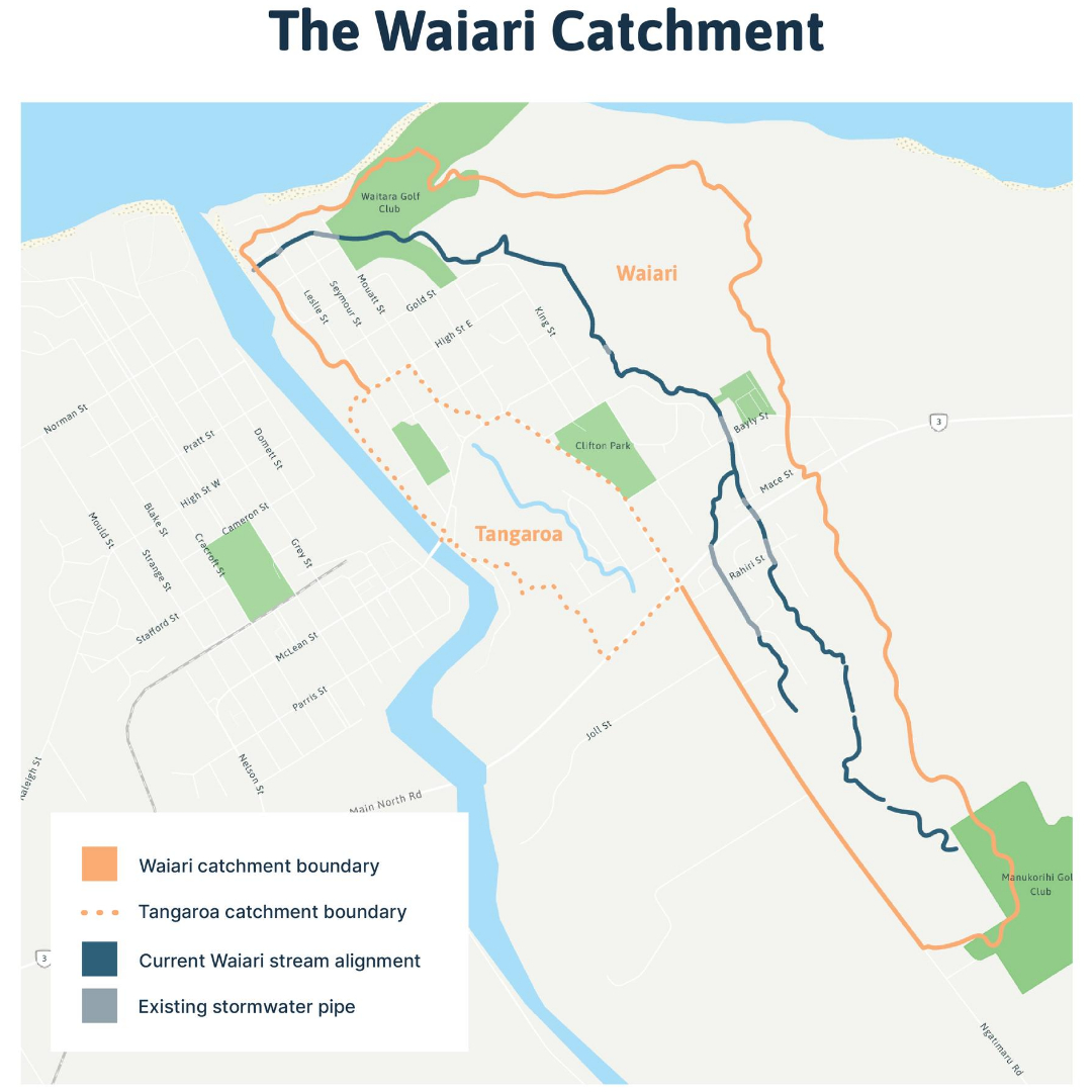
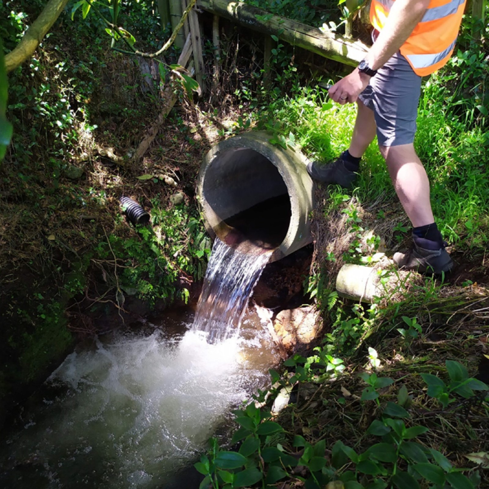
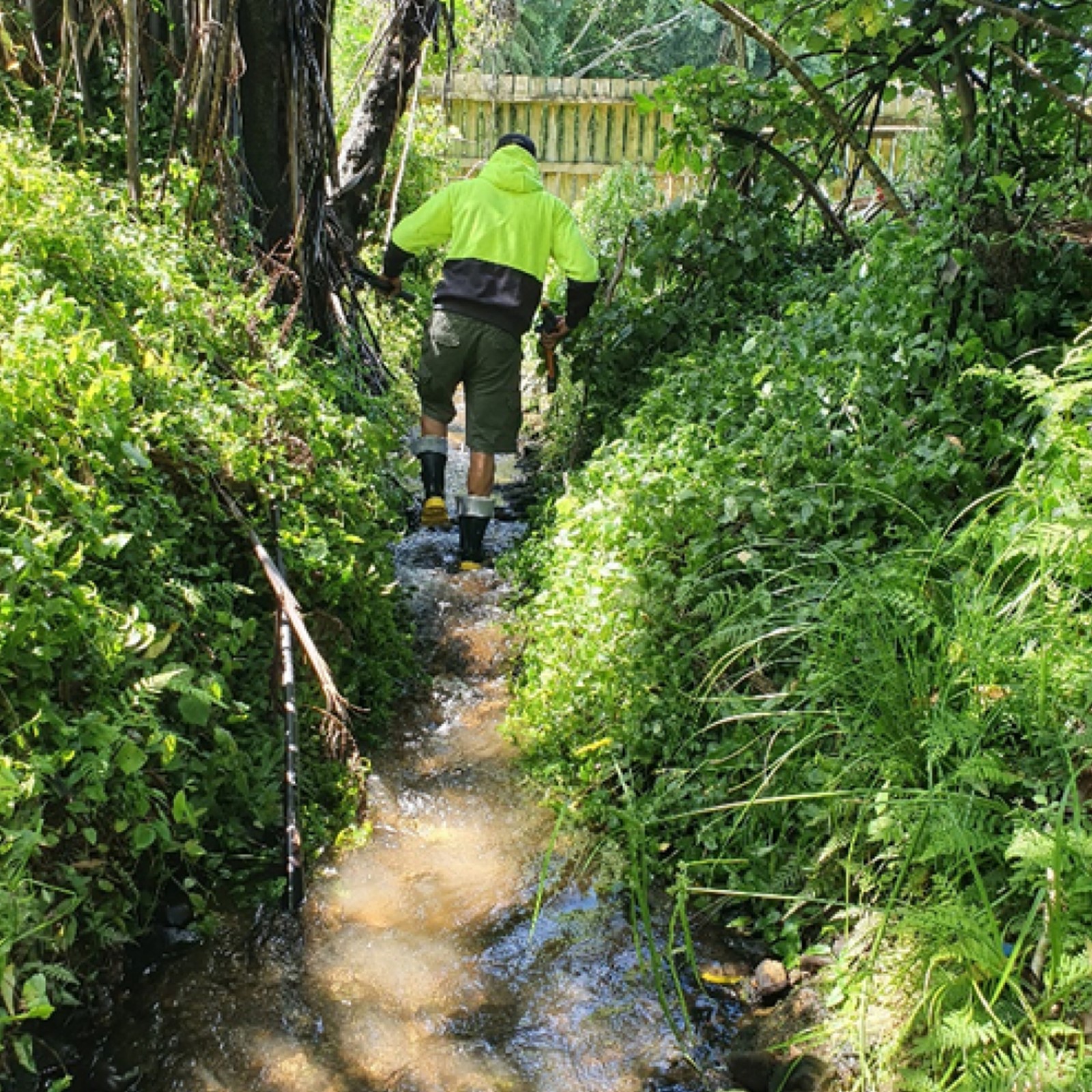
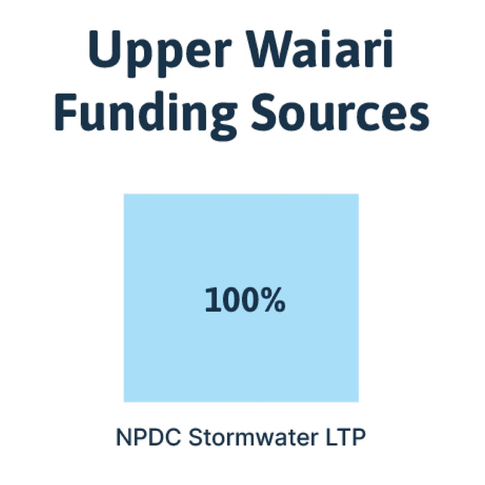
- Waitara stormwater issues
- Ōkato road safety improvements
- Redevelopment of Colson Road Landfill site
- Let's Go: Your Way - revised designs
- Draft Future Development Strategy 2024-2054
- Long-Term Plan 2024-2034 Financial Policies
- Be one of our Pulse Checkers
- Council meetings
- Have your say at meetings
- How to make a submission or objection
- Public notices
-
Consultations
- Justice of the Peace
- Seniors
- Tangata whenua
- Welcome to New Plymouth
- What's on
-
Te whakamahere i tō mātou a meake nei
Planning our future
Te whakamahere i tō mātou a meake nei Planning our futureMore about Planning our future
- A greener district
- Annual Plan
- Climate response
-
District Plan
Mahere a rohe District PlanMore about District Plan
- Proposed District Plan - Decisions version
-
Operative District Plan 2005
Mahere whakahaere ā-rohe 2005 Operative District Plan 2005More about Operative District Plan 2005
- District Plan review
- Have your say
- Hearings
- Long Term Plans
- Ngāmotu New Plymouth City Centre Strategy
- Our vision
-
Projects
Ngā Hinonga ProjectsMore about Projects
-
Water Projects
Water ProjectsMore about Water Projects
-
Transport Projects
Transport ProjectsMore about Transport Projects
- Infrastructure Projects
-
Previous projects
Previous projectsMore about Previous projects
- Ngamotu Road safety improvements
- New Plymouth Transfer Station relocation
- Reservoirs construction project
- Parklands/Mangati roundabout
- Bromley Place Reserve Playground
- Waiwaka Terrace
- Bell Block water main replacement
- Mangorei Road safety improvements
- Poet’s Bridge and Boat Shed Bridge
- Te Rewa Rewa Bridge repaint
- Tukapa Street
-
Water Projects
- Proposed District Plan
- Reforms
- Strategies, plans and policies
-
Kaunihera
Council
Kaunihera CouncilMore about Council
-
About the Council
Mō te Kaunihera About the CouncilMore about About the Council
- Citizens' and Youth Awards
- Council controlled organisations
- Council people
- Covid-19 information
-
Elections
Ngā kōwhiringa pōti ElectionsMore about Elections
- Our vision
- Sister cities
- Who we are
- Register of member’s pecuniary interests
- Bylaws
- Council meetings
- Employment
- Forms and fees
- Have your say
- Hearings
- News
- Public notices
-
Reports and publications
Ngā pūrongo me ngā whakaputanga Reports and publicationsMore about Reports and publications
- Publications
-
Reports
Ngā Pūrongo ReportsMore about Reports
- Annual reports
- Councillors Code of Conduct
- CouncilMARK™ Reports
- District wide safety review
- Liquefaction hazard in the Taranaki region
- Local Governance Statement
- NPDC Community Survey
- National Policy Statement - Urban Development
- Representation Review 2021
- Standard and Poor's Reports
- Long-Term Plan 2024-2034 Pre-Engagement
-
Strategies, plans and policies
Rautaki, mahere me ngā kaupapa here Strategies, plans and policiesMore about Strategies, plans and policies
-
Strategies
Ngā Rautaki StrategiesMore about Strategies
- Art in Public Places Strategy
- Central Area Urban Design Framework
- Coastal Erosion Strategy
- Coastal Strategy
- Collaborating for Active Spaces and Places Strategy
- Community Halls Strategy
- Cycle Strategy
- Digital Strategy
- Economic Development Strategy - Tapuae Roa
- EV Fast Charging Framework
- Financial Strategy
- Heritage Strategy
- Infrastructure Strategy 2021-2051
- Major Events Strategy
- New Plymouth Central Area Urban Design Framework
- New Plymouth District Alcohol Strategy 2009-2014
- Ngāmotu New Plymouth City Centre Strategy
- Open Space, Sport and Recreation Strategy – 30 Years
- Parking Strategy
- Positive Ageing Strategy
- Stormwater Vision and Roadmap
- Youth Strategy
-
Policies
Kaupapa here PoliciesMore about Policies
- Advertising Signs on Reserves Policy
- Agility Fund Policy
- Appointment and Remuneration of Directors of Council Organisations Policy
- Approval of Properties for Sale and Method of Sale Policy
- Approval to Attend Professional Development Events Policy
- Camping Ground Policy
- Closed Circuit Television Policy
- Commercial Trading in Public Places
- Community Funding Investment Policy
- Community Gardens Policy
- Community Hall Hireage Policy
- Dangerous and Insanitary Buildings Policy
- Development and Financial Contributions Policy
- District Licensing Committee Administration Policy
- District Tree Policy
- Dog Control Policy
- Drinking-water Quality Policy
- Easter Sunday Shop Trading Policy
- Elected Members’ Allowances and Recovery of Expenses Policy
- Elected Members Overseas Travel Policy
- Election Hoardings on Council-owned Property
- Encroachment Licences for On-Street Dining Policy
- Encroachments on Road Reserve Policy
- Enforcement of Vehicle Safety Requirements Policy
- Events in Council Administered Parks and Reserves Policy
- Fences on Road Reserves Policy
- Forestry Policy
- General Policies for Council Administered Reserves 2006
- Govett-Brewster Art Gallery Policy
- Graffiti Vandalism Policy
- Heritage Trails Policy
- Honorary Ambassadors Selection Criteria Policy
- Housing for the Elderly Policy
- Incentives to Provide Stock Underpass Policy
- Local Alcohol Policy
- Local Approved Products Policy
- LGOIMA Policy
- Maintenance and Management of Formed Roads Policy
- Memorials in Public Open Spaces Policy
- Milk Tanker Entranceways Policy
- New Plymouth District Class 4 Gambling Policy
- New Plymouth District Citizens' and Youth Award Policy
- New Plymouth District TAB Venues Policy 2010
- Ngā Whare Ora Taiao o Ngāmotu (New Plymouth Sustainable Homes Voluntary Targeted Rate Scheme) Policy
- Parks Strategy and Reserve Management Plan Implementation Fund Policy
- Privately Owned Redundant Underground Storage Vessels on Private Property Policy
- Procurement Policy
- Provision of Parking Facility on Road Reserve Policy
- Rapid Rural Property Numbering Policy
- Rates Remission and Postponement Policies
- Reduction to UV Exposure Policy
- Remuneration and Reimbursement for External Appointments to Council Committees and Working Parties Policy
- Remuneration of Council Employees Policy
- Revenue and Financing Policy
- Road Naming and Numbering Policy
- Rural Road Impact of Subdivisions Policy
- Significance and Engagement Policy
- Smokefree Parks and Outdoor Areas Policy
- Street Appeals and Collection Policy
- Sustainable Lifestyle Capital Reserve Policy
- Temporary Road Closure and Disruption to Traffic Policy (Events)
- Treasury Management Policy
- Weld Road Campsite
-
Plans
Ngā Mahere PlansMore about Plans
- Annual Plan
- Asset management plans
- Community board plans
- District Plan
- Land Development and Subdivision Infrastructure Standard (Local Amendments Version 3)
- Long-Term Plans
- New Plymouth District Blueprint
- Parks and reserves management plans
- Waste Management and Minimisation Plan
- Yarrow Stadium Strategic Plan and Asset Management Plan
- Emissions Reduction Plan
-
Strategies
- Working with us
-
About the Council
- Contact Find by A–Z